I drafted this post months ago, immediately following the ride on 27 February, 2021. However as some photos were missing, part of the route had to be repeated. Unfortunately I never got around to it … until June this same year. So, this story is published backdated to the day of the event it describes, to reflect the diary-like way most content finds its way onto tiggertracks.com. The photos taken in June are easy to identify as nature had finally gotten rid of the winter feel and added much more green to the picture. Enjoy!
The new year is in full swing. And just as the old one ended, every day a cacophony of headline news attacks my senses. I want to shut it out. Yet I also want to be on top of what is happening outside.
Outside.
Having cycled all through both winters, from 2019 to 2020 as well as this latest one, neither cold air nor the prospect of icy roads kept me from riding my bike into the surrounding hills and swamplands.
But I was tired after an uncommonly early onset of winter, of short days and dark nights spent mostly indoors because of a local curfew from 8 pm to the morning. Frantic hill repeats up the Weißer Stein were great to bring my monthly Strava Climbing Challenge within reach. Yet they no longer quench my thirst for exploration, for seeing places, for freedom.
Recently, a court order had ended that nightly curfew, for the time being at least. I was no longer bound by the 20:00 limit, and it felt safe to include some “experiments” on paths less pedaled.
I needed a full day on the bike. I needed to feel exhausted and to connect some dots. Even if that meant riding through the night. Or, rather, “especially if”.
All The Waytypes
On Thursday night, I reviewed a couple of my rides on RideWithGPS.com and cobbled them together. By Friday I had plotted a route of about 200 km and 3,000+ meters of elevation. Sure enough, the resulting itinerary was mostly tarmac.
But it would also take me over a bunch of forest roads, of which some seemed to be little more than stretches of packed dirt. The route would also pass through some as of yet untouched VeloViewer tiles which meant going places I’d never before visited by bike.


Weather forecast was for a bright, dry, but also very cold day. And temperatures would rapidly drop again around sundown. As I had calculated for the ride to take altogether about 12 hours, I’d have to take some extra kit and pause as little as possible. The latter is usually an issue with all the photo “opportunities” around ?
What made my planning somewhat vague was that all of the unknown portions of the route were “off-road”.
I was in for literally every way type imaginable.
Late As Planned
Intentionally, I left somewhat late, around 09:30 in the morning when the sun would begin to be noticeable. I tried to keep a good pace but to not sweat too much. There’s nothing worse than being damp and with a wet back shivering in cold weather.


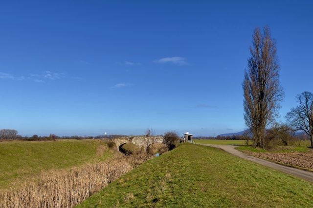
The first two hours of the ride mostly led through the Rhine valley between Mannheim and Bensheim. Plenty of sun, some fierce wind not directly from ahead but enough so that it was uncomfortable. To mix things up I had deliberately included a totally unpaved, grassy portion that would pass by the old double-arched stone bridge formerly carrying the postal route between Worms and Heppenheim over one of the arms of the tiny river Weschnitz.


Traffic Laws
In downtown Bensheim, I took a wrong turn off a cycle path and while carefully weaving my way through the narrow streets was stopped by police. As we are not required to wear face masks while cycling outside, I wasn’t wearing mine (I always have one at hand, plus one spare still sealed and safely stowed away). However the officer was more interested in reminding me that I was not permitted to cycle through the pedestrian zone. A somewhat confusing conversation ensued in which my bike was classified as “sports equipment”, hence not road-safe for lacking spoke reflectors and such.
Actually, except for not having StVZO*-approved reflectors on pedals and spokes my CAAD12 exceeds road safety standards and regulations, with even my bright Supernova Airstream front and rear lights certified for use in Germany. Dreading that legal rabbit hole I briefly pointed at all the 3M reflective tape covering the bike and at four reflective tabs on each wheel. Then I took off at the very first opportunity offered by the actually very friendly representative of the law.
(*=StVZO, or “Straßenverkehrszulassungsordnung”, is the German law regulating road vehicle safety. With regards to bicycles it is probably as far from being realistic and up to technological progress as the year it was first conceived. But that’s a different story.)
Local Legends, Local Food
In Bensheim the climbing started. Initially almost a “false flat” it gradually and relentlessly steepened over the next 10 kilometers.
When I passed the so-called “Felsenmeer” the gradient had reached 7%. That spot is a popular hiking destination and tourist attraction on the southern slopes of the Felsberg mountain: For thousands of years the naturally broken-up boulders and huge blocks of stone have been sourced by whoever lived and reigned here. Many examples of Roman masonry remain at the site still today. And of course, there are plenty fictitious explanations for these natural and man-made rock formations available to those who prefer to dream and fantasize.
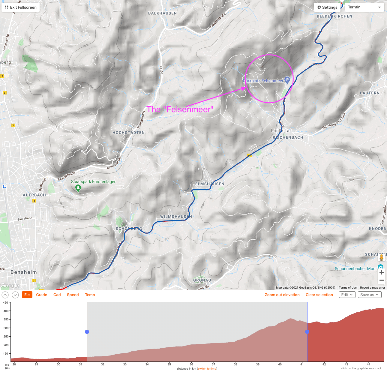
I slowly ground my way upwards along the shadowy and cold northern side opposite of that natural open-air quarry. A few years earlier I had descended this narrow and winding road when it was being resurfaced. Now the pristine tarmac was lined by tiny swathes of snow preserved in ditches and depressions alongside. Feeling hungry and with my route soon leading into the less populated valleys of the Odenwald I needed to refuel.
While riding through the village of Asbach I asked around for a bakery. Apologizing for the only shop being closed someone pointed me towards a butcher’s in neighboring Rodau: “If you can live with something salty instead of sweet, they are excellent.” — Although I will happily live off a vegetarian or even vegan diet, I eat basically everything. And I do like meat, at least occasionally. And that tiny shop did not disappoint.
During a short break I mused about what the owner had just responded to my well-wishes: “Let’s wait and see what remains once the pandemic is over.” — For these tiny towns and villages, gastronomy and weekend tourism are often at least as important as weekday commerce. With the former two being largely prohibited or at least reduced to a fraction of their pre-COVID scale and the latter suffering badly the outlook is much less bright than the sunny spot by the local town hall where I was just now eating my lunch.


Odenwald Cols
The journey continued on a narrow lane, an old connection between Niedernhausen and Wersau, that turned from broken tarmac to gravel to forest track proper within a minute. It went straight up the wooded hillside at a double-digit gradient. Pure fun, until short before the summit, in the middle of the forest, some local turned his electric car headlong into my direction. He could have stopped. Or just respected the fact that there were plenty signs reserving the right of way to farmers, forest workers and people on bicycles and horses, prohibiting most motorized vehicles.


Eventually, my journey touched the gentle, fertile hills between Hippelsbach and Ober-Klingen, an area also cultivated since at least Roman times. Exhilarating views from the small settlement of Hundertmorgen seemed to encompass all southern Hesse. And I found my daily dose of cobbles. Then I was passed by a ginormous tractor pulling a trailer with an even bigger tank full of some chemicals with which the driver appeared in a hurry to spray fields of crops that would likely be sprouting within a few weeks time. Quite the contrasting feelings over such a short distance.


From Brensbach through Nieder- and Ober-Kainsbach I reached the rather unimposing summit of Spreng. This “Col” could just as well be situated somewhere in the Vosges or the Pyrenées foothills. Forest on the slightly higher hilltops all around, green pastures and fields in the valleys below. The scenery opened up to a plateau where about a dozen major and minor roads, country lanes and forest tracks converge. One of the latter again named “Hohe Straße” or “Höhenstraße”, depending on which source you trust, hinted at a more glamorous past. It would be my first true off-road intermezzo of the day.


Forest Roads
And I wasn’t the only one feeling adventurous: First a car that had obviously taken a wrong turn was now slowly reversing out of the dirt road. Its driver was careful not to get stuck with what definitely wasn’t a 4WD. Then a group of hikers, spread out over several dozen meters along a climb, bemusedly watched me fighting to maintain a constant cadence while resolutely navigating the deep tracks of packed dirt up into the dense woodland. A short while later I was happily cycling over much better-maintained gravel. Excellent. No hike-a-bike yet.
Further down into the forest, the road kept a pretty straight line atop the hilly terrain, mainly running along the ridge. As it was practically still winter, at least according to calendar and temperatures, leaves covered the ground but not the trees, letting a lot of daylight through.


I passed a sign presumably containing some historic details and turned around for a read. The sign was put up beside a stone table (as in a desk made from stone). There are many such tables to be found in the region and elsewhere, and they all have their own stories to tell. Many marked places where laws and treaties would be discussed, decided and upheld. Or, as in this case, they were meeting places and rest stops for feudal hunting parties, centuries ago … and this particular table has had two benches added to it in recent times for it to serve as a picnic spot for everyone, not just blue-blooded nobility.
Around the site of this stone table, or “Steinerner Tisch”, a tale exists that is a bit too grim to write about here. But suffice to say it talks most literally of “an eye for an eye” between some locals.
The atmosphere today was far from grim. Lots of people out and about. A few hundred meters further down the road I passed a long-distance runner. We nodded towards one another in encouragement.
Borderline Cycling
Initially everything was fine. This double track had obviously been an important thoroughfare centuries ago, and sure enough did I reach a former demarcation point. At a clearing in the middle of the woods, a place called “Am Schlagbaum” (“By the Turnpike”) indeed marked the site of a former toll station at an intersection of seven roads from and to former feudal territories.

When I left the forest after about five kilometers my route took a half turn right back into what could only be described as single track. I stopped for an instant, but then sensed the grin on my face widen and wiping away anxiousness and doubts.
Luckily it hadn’t rained recently and I was mostly just rolling and skidding downhill over dry leaves. Still no need to get off and carry my bike.


Some steep and sketchy descents later — and under the calm and watchful gaze of a huge black horse — I reached “Oberdorf” which literally means “Upper Village” as this picturesque collection of farmhouses is situated higher up on the slopes overlooking the village and valley of Rohrbach.
Right about when I turned towards the tarmac roads of the village, I noticed a movement out of the corner of my eye: A silhouette came towards me in long strides. It was that same runner I had passed before. Now he passed me and, a fleeting grin and nod later, disappeared into the forest again.


Off The Charts
Leaving Rohrbach I recognized the “Mossauer Weg” linking the valleys of Unter-Ostern and Über-Ostern in the west with Ober-Mossau and the Mossau valley in the east. Between my cycling buddy Carlo and myself, this area, and specifically this minor road had quickly become one of our favorites after participating in a Grand Fondo style event in 2017. Unfortunately it is so far out that we usually need a 150+ km ride just to touch it, even more to achieve some variation in the routes taken.

A short while, some deliberate detours (to add more meters of climbing) and not that many kilometers later I arrived at another summit, the “Wegscheide” which literally means “crossroads”, as in “standing at a crossroads”.
Just another hilltop where several roads and tracks meet, very much like the one at Spreng just before, it was here that I’d knowingly plotted my itinerary deep into the forest and off the beaten track. I wanted to “paint” two VeloViewer tiles that — according to all the maps I had consulted — were decidedly out of reach for road bikes. Those maps didn’t even agree on the tracks and paths someone had drawn on one and then ominously omitted from another.
But with the dry weather of the past week and what appeared to be ancient roads connecting the many hamlets and villages I was optimistic. Yet, my earlier forest escapade had put me somewhat behind my schedule already. My ride had almost reached its halfway point. Could I still manage another two or three experiments?
Then I saw that same runner emerge from among the trees for a third time. Neither of us could stifle a laugh. There definitely was a way through the forest.
Pest And Persistence
From where the runner had come I heard the roar of machines. I hadn’t considered the large-scale felling of trees that currently dominates forestry all around. And sure enough, a giant harvester and a not less formidable truck were busy cutting and loading trunks of enormous trees that now had to “disappear”, because of massive and widespread bark beetle infestation all over Germany and beyond.
Main forest roads soon proved impassable. And the minor ones I then turned onto had often been cut right through by newly cleared access ways and hastily created clearings with deep muddy tracks.
Seeing that the various maps I had downloaded onto my iPhone showed tracks that were either nonexistent or completely overgrown wasn’t reassuring.
But I kept riding my bike. As often and as much as possible that is.
I won’t complain: I got what I asked for and it was a lot of fun navigating the bike and myself on 30 mm slicks and on foot up and down the hilly terrain and through undergrowth.

Sometimes the half-joking half-serious warning my friend Ansgar had posted a few weeks earlier came to mind: Since September 2020 an adult male wolf (identified as “GW1832m”) originally from northern Italy seemed to now be roaming these woods. I didn’t see neither GW1832m nor any other wildlife though. And I wouldn’t have expected to anyway — too noisy was my clumsy progress, riding, pushing and carrying my bike through mud, ankle-deep leaves & twigs and over fallen trees.
Eventually I emerged into the Mossautal. Late afternoon sun bathed the landscape below and on the other side of this central Odenwald valley in deceivingly warm colors.


Altogether, these first two off-road episodes had taken about two hours longer than anticipated. With the sun already beginning to set, I decided to shorten my planned ride by roughly 20% of distance, elevation and leave further exploration for another day:
Instead of continuing along the eastern edge of known territory I’d take an almost diagonal, yet meandering route passing through Wald-Michelbach and eventually leaving the Odenwald hills via that iconic climb up to the Ursenbacher Höhe and beyond.

Cold
Relative to the remaining distance this shortcut wouldn’t mean less elevation, but in absolute numbers I’d save at least 1.5 hours and more than 400 meters of climbing. Also, I knew the way, so I could pace myself well and should still be home on time. But I wasn’t expecting negative Celsius temperatures on the way back ???


I had merely reached Olfen when my Wahoo signaled 0°C for the first time. And while actual, measured temperatures still oscillated as far up as +2°C, it felt much colder than even the -1°C I encountered, especially while descending.
After the sun had finally set, the remainder of my journey was illuminated by my headlights as well as by a stunning full moon hung low on a beautiful night sky. These final 2.5 hours took me through Siedelsbrunn, down the technical but always fun hairpins and turns from Unter-Abststeinach to Trösel and then over what we know as “Kamelbuckel” (camel humps), a series of short, punchy climbs up towards Oberflockenbach.


Right here I saw a woman walking a giant dog on a leash. Although I have a tendency to stop for a chat with cats, dogs and horses (and with their respective human counterparts if they are so inclined), with how cold I was I would rather have passed the opportunity. But the dog was obviously young, very attentive and extremely sociable. To the delight of that 40 kg furball I decided to have a 10 minutes “conversation”.
But then I had to push onwards. Temperatures hovered around freezing, I was in bib shorts (plus knee warmers) and still had more than an hour ahead of me. To warm myself up again, I stuck to the plan of climbing the Ursenbacher Höhe, followed by what would be a freezing-cold long descent via Schriesheim plus the notoriously similarly cold flat transit towards Ladenburg. It also allowed me to perform another “ritual”.


“hic sunt dracones”
https://en.wikipedia.org/wiki/Here_be_dragons
Off-road exploration can be exciting. You never know exactly what to expect. But one thing you will encounter for sure when leaving somehow prepared and surfaced ways: there will be dirt. And depending on soil and climate as well as your skills and equipment, you may be in over your head.
Underbiking describes best what I enjoy during those limited escapes from teutonically overbuilt road infrastructure. While I don’t mind pushing or even carrying my modified road bike, I always challenge myself to staying in the saddle and on my pedals for as long as possible. Handling skills are vastly underrated, especially when not on chunky tires, fully suspended on a bike designed for charging through trails and over rocks at speed.
The CAAD12 by now actually resembles more a mountain bike than the classic road racer as which it was born: With the increased flexibility of a “clutched” and customized MTB drivetrain and a modestly flared handlebar me and my “acid red” Frankenbike are a regular sight on many a steep gravel climb. It is hilarious to watch the expression on the faces of fully-clad eMTB riders when we emerge from between some rocks or trees where they least expect skinny racing tires.


Clean
All these dusty adventures also mean that we look the part on our return to my apartment in downtown Mannheim. For lack of a backyard with running water or any other easily accessible place to wash the bike, I either have to thoroughly clean the bathroom after granting myself and bike a proper shower (in that order, not at the same time). Or, and that’s what has become a ritual whenever my rides take me back via Schriesheim or Heidelberg, I make a slight detour in the name of cleanliness:
Most pressure washers are not a good idea to use on bikes. It’s far too easy to drive grease out of sealed bearings at pivot points (suspension), hubs and axles. At the same time dirt and water are likely to be pushed past the rubber seals, vastly accelerating corrosion and wear. But not so at a self-service car wash in Ladenburg:
Insert a coin, and while you don’t yet pull the trigger, the contraption “defaults” to a low setting that is perfect for the purpose (unless you aim directly at any bearing, that is). And a first quick once-over with the dial on “clean” adds a bit of detergent to the mix that will get rid of all muck and grime accumulated on rural, wintry roads.
I then switch to “rinse” for most of the wash cycle, and my bike (as well as the soles and cleats of my MTB shoes) are apartment-safe again. The rest of the ride back home is short (12 km), exclusively on tarmac, not too dirty, and it also helps drying bike and drivetrain by shedding water from between chain links: I am now into the second year of waxing my chains instead of lubing them with mineral oil-based products. Dirt easily comes off the chain with just water and a drop of dishwashing liquid. Just be sure to properly rinse and dry everything.


(The second picture is a post-wash snaphot of my other bike, just to make a point.)
Home
At home I wipe the chain with a lintless cloth to remove any dust it might have picked up over the final stretch, wait another hour or more to ensure it is completely dry, and before dinner or before going to bed apply one drop of a liquid, wax-based lube to the inside of each roller. All-in-all the post ride process (including the car wash) requires about 5-10 minutes attention.
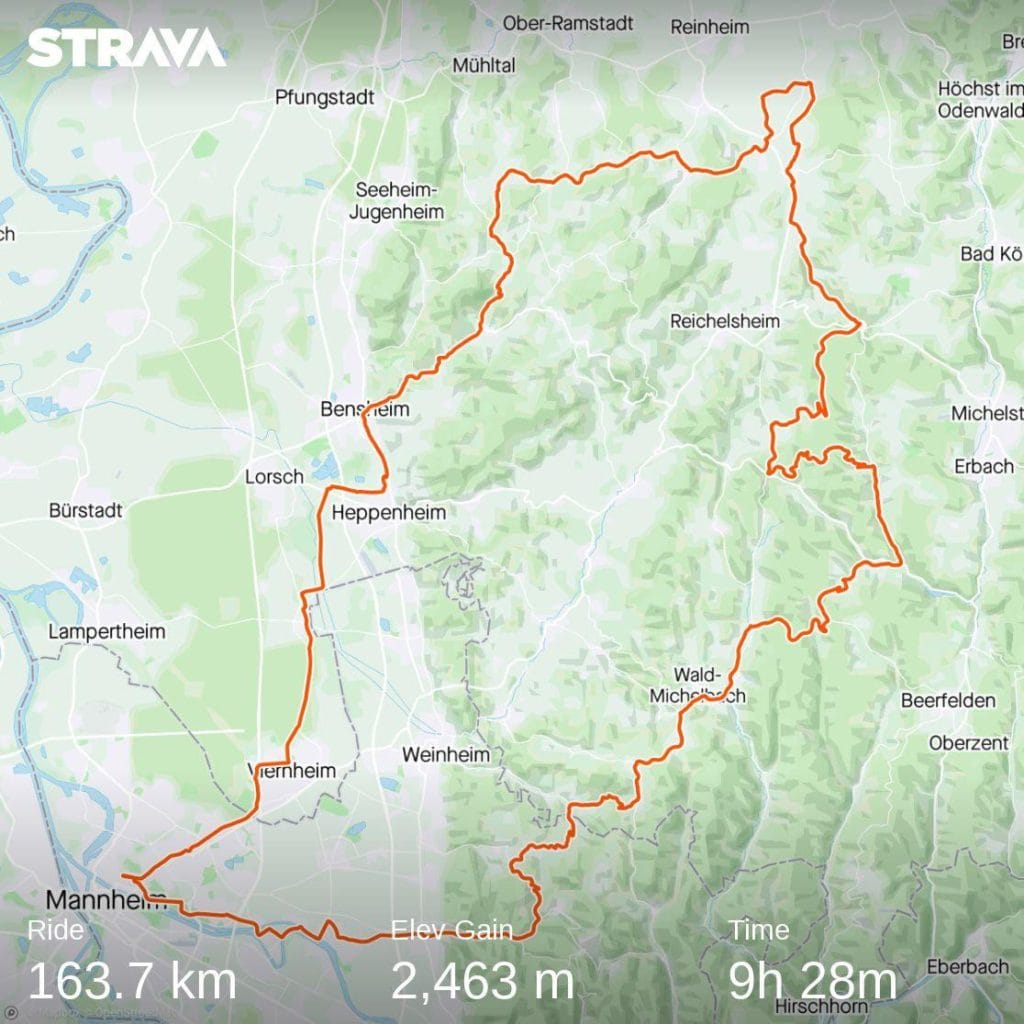
On this evening, everything was dialed to perfection: My dinner warmed up on the stove and I was out of the shower and into comfy clothes in no time. I checked the ride numbers in the Wahoo app and then uploaded everything to Strava: 163 km, 2,463 m elevation, with an average temperature of 4° Celsius. And I had completed the “mandatory” portion of my VeloViewer epxloration: 10 tiles “painted”, i.e. touched by me, bike and mascot.
But I still had some leftovers to deal with. This would have to wait for another ride though. With that area and its forest trails being on the extreme end of what we usually ride in a single roundtrip — and with COVID-19 restrictions on/off all around — one can never reliably plan such full day rides.


Just before bed another message popped-up on the iPhone: My cycling buddies were already planning to take me on another mixed tarmac-gravel adventure early the next morning. That seemed a bit … ambitious?!
But, hey, unlike that famous British spy most of us only live once! Also, I didn’t feel bad, just exhausted in a good way. Moreover, I was still some 600 meters away from completing the February Climbing Challenge. And my bike was ready, as was another set of bike kit.